Storm System Will Hit Northeast After Comfortable Start To Week: Timing Storm System Will Hit Northeast After Comfortable Start To Week: Timing
Storm System Will Hit Northeast After Comfortable Start To Week: Timing A stretch of crisp, comfortable weather across the Northeast will give way to a more unsettled pattern later this week. The National Weather Service says mostly sunny skies and low humidity will dominate Tuesday, Aug. 25, with highs generally in the upper 70s to low 80s. Fair conditions are expected to hold through much of Wednesday, Aug. 26, before the next disturbance approaches.  Wednesday will remain dry for most of the region, with temperatures around 80 degrees and light winds, according to the National Weather Service. The change becomes more noticeable Thursday, Aug. 27, as wa…
New Tropical Threats Being Watched In Atlantic: What To Know New Tropical Threats Being Watched In Atlantic: What To Know
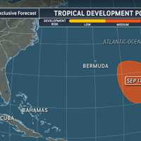
New Tropical Threats Being Watched In Atlantic: What To Know The Atlantic hurricane season is entering a busy stretch, with forecasters tracking several areas of interest for possible tropical development. The National Hurricane Center is monitoring three disturbances across the Atlantic basin, including a tropical wave expected to move off Africa and two areas with lower potential for development. None of the systems currently pose an immediate threat to the continental US, according to the National Hurricane Center. The area with the highest development potential is a tropical wave expected to emerge over the Atlantic after moving off the west coa…
30-Second Tornado Confirmed In Egg Harbor Township, NWS Says 30-Second Tornado Confirmed In Egg Harbor Township, NWS Says
30-Second Tornado Confirmed In Egg Harbor Township, NWS Says A tornado that lasted just 30 seconds or less has been confirmed in South Jersey, the National Weather Service said. The tornado touched down about four miles southeast of Estell Manor in Atlantic County at 4:41 p.m. Thursday, Aug. 20, the NWS Mount Holly office said in an updated storm survey Saturday, Aug. 22. Video posted to social media and taken along the Great Egg Harbor River in English Creek, Egg Harbor Township, captured the tornado across the river in Estell Manor, according to the NWS. A tornado that lasted just 30 seconds or less has been confirmed in South Jersey, the N…
2 Tornadoes Tear Through PA, Including York, As EF2 With 120 MPH Winds Rips Off Roofs 2 Tornadoes Tear Through PA, Including York, As EF2 With 120 MPH Winds Rips Off Roofs
2 Tornadoes Tear Through PA, Including York, As EF2 With 120 MPH Winds Rips Off Roofs Two tornadoes tore through York and Lancaster counties within minutes of each other, including an EF2 packing 120 mph winds that ripped roofs off parts of Eastern York High School, the National Weather Service confirmed Friday night, Aug. 21. The stronger tornado touched down south of Wrightsville at 4:24 p.m. Thursday, Aug. 20, carving a 1.07-mile path through eastern York County before lifting just two minutes later, according to the NWS damage survey. Just four minutes after that tornado lifted, an EF1 with estimated peak winds of 100 mph touched down in Columbia Borough, where buildings…
VIDEO: Tornado Rips Through Long Island Beach Club, Damaging Cabanas, Buildings VIDEO: Tornado Rips Through Long Island Beach Club, Damaging Cabanas, Buildings
Video: Tornado Rips Through Long Island Beach Club, Damaging Cabanas, Buildings A tornado that began as a waterspout off Long Island tore through a private beach club, damaging dozens of cabanas and other structures and forcing two clubs to close indefinitely. The tornado touched down at the far west end of Atlantic Beach between 6:30 and 7 p.m. Thursday, Aug. 20, the National Weather Service confirmed. Radar, video of the waterspout coming ashore, and damage near the Sun and Surf Beach Club confirmed the touchdown, the agency said. Sun and Surf, located in the Village of Atlantic Beach, said the tornado caused "significant damage to numerous cabanas and buildings." V…
Famed Storm Chaser Captures NJ Supercell, Waterspout Amid Tornado Threat Famed Storm Chaser Captures NJ Supercell, Waterspout Amid Tornado Threat
Famed Storm Chaser Captures NJ Supercell, Waterspout Amid Tornado Threat A famed storm chaser had a front-row seat as powerful supercells swept across the region amid a tornado threat Thursday, Aug. 20. Reed Timmer, an extreme meteorologist with a PhD in meteorology from the University of Oklahoma and 3.6 million followers on Facebook, shared four videos from the storms as he chased them across Delaware Bay into southern New Jersey. Across the videos, Timmer captured a waterspout off Fortescue Beach and massive supercells crossing Delaware Bay into southern New Jersey, some of which he said produced waterspouts. "Watch this tornado warned supercell cross D…
Tornadoes, Damaging Winds Possible As Severe Storms Take Aim At DC, Maryland, Virginia: NWS Tornadoes, Damaging Winds Possible As Severe Storms Take Aim At DC, Maryland, Virginia: NWS
Tornadoes, Damaging Winds Possible As Severe Storms Take Aim At DC, Maryland, Virginia: NWS Enjoy the quiet while it lasts. A muggy Thursday could take a nasty turn across DC, Maryland and Virginia as the afternoon wears on, with severe storms threatening to bring damaging winds, hail, flooding and even a few tornadoes into the evening, forecasters say. The timing isn't ideal. Storms are expected to begin firing during the afternoon before becoming more widespread through roughly 4 to 6 p.m., putting parts of the Baltimore-Washington corridor in the crosshairs around the evening commute, according to the National Weather Service. Much of the region east of the Blue Ridge is unde…
Snowier Winter Ahead? Map Reveals Possible Pattern As Super El Niño Chances Soar Snowier Winter Ahead? Map Reveals Possible Pattern As Super El Niño Chances Soar
Snowier Winter Ahead? Map Reveals Possible Pattern As Super El Niño Chances Soar Winter’s first meaningful signal is getting louder, but the Northeast still faces a familiar wildcard: snow or rain. NOAA’s Climate Prediction Center said Thursday, Aug. 13, that El Niño is strengthening, with a greater than 90 percent chance of becoming very strong this fall and winter. Forecasters also see a 69 percent chance that its strength from October through December will exceed every El Niño event recorded since 1950. Sea-surface temperature differences have exceeded 3.6 degrees F, or 2 degrees C, above average in the eastern equatorial Pacific. The changing ocean and atmospheric …
Winter Outlook Warns Of Complicated Pattern: Farmers' Almanac Predicts 'Heavy, Wet Snow' Winter Outlook Warns Of Complicated Pattern: Farmers' Almanac Predicts 'Heavy, Wet Snow'
Winter Outlook Warns Of Complicated Pattern: Farmers' Almanac Predicts 'Heavy, Wet Snow' A newly released long-range forecast is offering an early look at a winter that could prove especially tricky across the Northeast. The Farmers' Almanac says the 2026-27 season may bring sharp weather contrasts nationwide, with an unpredictable mix of precipitation expected across the Northeast. "The Northeast may face one of the season’s most complicated winter patterns," the Farmers' Almanac said. The outlook calls for a mix of rain, sleet, freezing rain, and snow, with the type of precipitation varying depending on storm tracks and temperatures. "Coastal communities could receive more …
Tornado Touches Down In Maryland After Waterspout Spins Ashore: National Weather Service Tornado Touches Down In Maryland After Waterspout Spins Ashore: National Weather Service
Tornado Touches Down In Maryland After Waterspout Spins Ashore: National Weather Service Mother Nature took Maryland for a brief spin. A waterspout that formed over the Patapsco River came ashore and turned into an EF-0 tornado at the Port of Baltimore at approximately 4:39 p.m. on Monday, Aug. 10, before cutting a two-mile path into Dundalk, according to a National Weather Service damage survey released on Wednesday. And while it was brief, the twister left its mark. The tornado packed estimated peak winds of 65 mph, grew as wide as 90 yards, and stayed on the ground for approximately six minutes before dissipating in Baltimore County at 4:45 p.m., forecasters said. No injur…
70 MPH Winds, Possible Tornadoes Possible In DMV As Storms Ground Flights At Major Airports 70 MPH Winds, Possible Tornadoes Possible In DMV As Storms Ground Flights At Major Airports
70 MPH Winds, Possible Tornadoes Possible In DMV As Storms Ground Flights At Major Airports Mother Nature came out swinging Monday afternoon. Violent thunderstorms packing winds up to 70 mph tore across Maryland on Aug. 10, bringing warnings of falling trees, flying debris, blocked roads and power outages as forecasters cautioned that tornadoes could develop quickly. Then the storms started wreaking havoc in the skies. By around 4 p.m., the FAA had issued simultaneous ground stops for flights bound for Baltimore/Washington International Thurgood Marshall Airport, Ronald Reagan Washington National Airport and Washington Dulles International Airport because of thunderstorms. All t…
Old Farmer's Almanac Releases Fall Forecast: What To Expect In Northeast Old Farmer's Almanac Releases Fall Forecast: What To Expect In Northeast
Old Farmer's Almanac Releases Fall Forecast: What To Expect In Northeast A new long-range outlook is offering an early look at what fall could bring across the Northeast. The Old Farmer's Almanac says cooler-than-average weather is expected across much of the eastern US this September and October, with notable differences in rainfall depending on location. For the Northeast, the Almanac projects below-average temperatures overall, along with wetter-than-normal conditions compared with historical averages. That pattern would mark a distinctly cooler turn for New York, New Jersey, Connecticut, Pennsylvania, and Massachusetts as the season progresses. The outlook…
Jaw-Dropping Photo Shows Car Submerged In Glen Rock Floodwaters After Victims Rescued Jaw-Dropping Photo Shows Car Submerged In Glen Rock Floodwaters After Victims Rescued
Jaw-Dropping Photo Shows Car Submerged In Glen Rock Floodwaters After Victims Rescued A jaw-dropping photo shows a vehicle nearly swallowed by floodwater after two people trapped inside were rescued during severe storms in Glen Rock Friday evening, Aug. 7. The Glen Rock Volunteer Fire Department responded to 15 flooding-related calls throughout the evening, the department said. One of the most serious incidents involved a vehicle trapped in floodwater with two occupants inside, firefighters said. As the vehicle continued filling with water, Glen Rock firefighters entered the water alongside the Glen Rock Police Department and pulled both occupants to safety, according to the…
New Round Of Storms With Heavy Rain, Flash Flood Threat Near Northeast: Updated Timing New Round Of Storms With Heavy Rain, Flash Flood Threat Near Northeast: Updated Timing
New Round Of Storms With Heavy Rain, Flash Flood Threat Near Northeast: Updated Timing A surge of moisture will fuel rounds of storms with drenching downpours and possible flash flooding. Click here for a new, updated story - Drenching Downpours Will Raise Flash-Flood Threat Across Northeast: Timing After scattered showers and storms on Wednesday evening, Aug. 5, warmer, more humid air will spread north along the East Coast on Thursday, Aug. 6, triggering storm activity. Highs will reach the mid- to upper 80s, with some interior locations nearing 90 degrees. A strengthening area of high pressure near Bermuda will help draw moisture northward, according to Ac…
Neighbor Helps Maryland Resident Escape After Massive Tree Crushes Fort Washington Home Neighbor Helps Maryland Resident Escape After Massive Tree Crushes Fort Washington Home
Neighbor Helps Maryland Resident Escape After Massive Tree Crushes Fort Washington Home A Maryland resident escaped without a scratch Tuesday morning after a massive tree came crashing through a two-story home in Fort Washington, thanks in part to a quick-thinking neighbor. The collapse happened around 9:30 a.m. on Aug. 4, in the 12900 block of Heather Circle in Prince George's County, where firefighters arrived to find the tree split through the middle of the house. According to the Prince George's County Fire/EMS Department, the occupant was able to self-extricate with assistance from a neighbor before crews arrived. No injuries were reported. Photos from the scene show the…
Tornado Watch Issued Across Maryland, DC, Northern Virginia As Severe Storms Move In Tornado Watch Issued Across Maryland, DC, Northern Virginia As Severe Storms Move In
Tornado Watch Issued Across Maryland, DC, Northern Virginia As Severe Storms Move In Maryland is under a Tornado Watch until 10 p.m. Tuesday as forecasters warn the atmosphere is primed for dangerous thunderstorms capable of producing tornadoes, damaging winds, large hail and flash flooding across much of the region. The National Weather Service issued an alert on Tuesday afternoon, replacing part of an earlier Severe Thunderstorm Watch as conditions became more favorable for tornado development. The watch includes Anne Arundel, Baltimore, Baltimore City, Calvert, Carroll, Cecil, Charles, Harford, Howard, Montgomery, Prince George's and St. Mary's counties, along with all o…
Flood Watch In Westchester: Drivers Should Watch Out For Fast-Flowing Waters, Officials Say Flood Watch In Westchester: Drivers Should Watch Out For Fast-Flowing Waters, Officials Say
Flood Watch In Westchester: Drivers Should Watch Out For Fast-Flowing Waters, Officials Say A Flood Watch has been issued for Westchester County as forecasters warn that a slow-moving storm system could bring repeated rounds of heavy rain capable of triggering dangerous flash flooding.  The National Weather Service said the Flood Watch is in effect from 8 a.m. on Tuesday, July 28, through Wednesday evening, July 29, for southern Westchester County and surrounding areas.   Forecasters said a strengthening low-pressure system will move slowly across the Northeast, producing multiple rounds of heavy showers and thunderstorms from Tuesday through Thursday. Because of th…
Purchase, Rye Brook Tornado Traveled 1.82 Miles, NWS Confirms: Track Its Path Purchase, Rye Brook Tornado Traveled 1.82 Miles, NWS Confirms: Track Its Path
Purchase, Rye Brook Tornado Traveled 1.82 Miles, NWS Confirms: Track Its Path A tornado touched down in Westchester during storms on Tuesday, July 21, the National Weather Service has confirmed. An EF-0 tornado developed at 4:10 p.m. in Purchase and traveled 1.82 miles east-northeast before dissipating at 4:17 p.m. in Rye Brook, according to the NWS. The tornado reached estimated peak winds of 85 mph and grew as wide as 40 yards, survey teams determined. No injuries or fatalities were reported. ALSO SEE: Four Tornados, 3 EF-1s, Confirmed In New Jersey The tornado likely began on the Manhattanville College campus, where it uprooted several trees and snapped…
NWS Details 4 Tornados That Ripped Through NJ During Tuesday's Storms NWS Details 4 Tornados That Ripped Through NJ During Tuesday's Storms
NWS Details 4 Tornados That Ripped Through NJ During Tuesday's Storms The National Weather Service has confirmed four tornadoes touched down in New Jersey during the severe storms that swept across the state on Tuesday, July 21. In an updated damage survey released Wednesday night, July 22, the NWS confirmed three EF-1 tornadoes struck Morris and Sussex counties, while an EF-0 tornado touched down in Cape May Point. No injuries or fatalities were reported in any of the tornadoes, according to the weather service. ROXBURY The strongest tornado developed in the Lower Berkshire Valley section of Roxbury Township at about 2:15 p.m., the NWS said. The EF-1 tornad…
2 Possible Tornado Paths Surveyed By NWS After Wild Storms Rock Morris County 2 Possible Tornado Paths Surveyed By NWS After Wild Storms Rock Morris County
2 Possible Tornado Paths Surveyed By NWS After Wild Storms Rock Morris County The National Weather Service plans to survey two possible tornado damage paths in Morris County on Wednesday, July 22, after severe storms tore through North Jersey and sparked widespread reports of funnel clouds and possible touchdowns. Survey teams will inspect one area stretching from the Stanhope area through Parsippany and another near Morristown to determine whether tornadoes formed during Tuesday, July 21's storms. A preliminary Public Information Statement is expected by Wednesday evening. A virtual survey is expected for Cape May Point, where the NWS said, "damage was sporadic and …
Did A Tornado Touch Down In Parsippany? Wild Video, Social Media Fuel Buzz Did A Tornado Touch Down In Parsippany? Wild Video, Social Media Fuel Buzz
Did A Tornado Touch Down In Parsippany? Wild Video, Social Media Fuel Buzz As severe storms swept across North Jersey on Tuesday, July 21, ominous skies over Parsippany sparked a wave of social media speculation that a tornado may have touched down. UPDATE: 2 Possible Tornado Paths Surveyed By NWS After Wild Storms Rock Morris County The US National Weather Service Philadelphia/Mount Holly tells Daily Voice: "We did receive a report of a tornado in that area earlier this afternoon. However, we will be doing a damage survey tomorrow to confirm." A photo shared on social media appeared to show a dark, funnel-shaped cloud extending from the storm clouds near To…
Cars Submerged, Thousands Lose Power As Flash Flooding Slams Fairfield County Cars Submerged, Thousands Lose Power As Flash Flooding Slams Fairfield County
Cars Submerged, Thousands Lose Power As Flash Flooding Slams Fairfield County Heavy rain has flooded roads, knocked out power to thousands, and prompted a flash flood warning and tornado watch across parts of Connecticut as strong thunderstorms swept through the region Tuesday, July 21. The National Weather Service issued the flash flood warning for Fairfield County and western New Haven County. A tornado watch remains in effect for Fairfield, New Haven, and Litchfield counties until 9 p.m. Tuesday. Middlesex County remains under a flood advisory. Click here to see updated weather alerts across the state. Cars Submerged As Flooding Worsens Forecasters said between 1…
Tornado Watch Issued For Parts Of Maryland As Dangerous Storms Move In Tornado Watch Issued For Parts Of Maryland As Dangerous Storms Move In
Tornado Watch Issued For Parts Of Maryland As Dangerous Storms Move In Parts of Maryland are under a Tornado Watch Saturday afternoon as forecasters warn a volatile mix of dangerous heat, powerful thunderstorms, flash flooding, and the potential for tornadoes could sweep across the region before the day is over. The National Weather Service issued the watch for central and northeastern Maryland until 9 p.m., covering Anne Arundel, Baltimore, Calvert, Caroline, Carroll, Cecil, Frederick, Harford, Howard, Kent, Montgomery, Prince George's, Queen Anne's, Talbot, and Baltimore City. The rest of the Baltimore-Washington forecast area, including DC and much of Virgi…
Pennsylvania Air Gets Even Worse: Here's When Smoke Will Finally Clear Pennsylvania Air Gets Even Worse: Here's When Smoke Will Finally Clear
Pennsylvania Air Gets Even Worse: Here's When Smoke Will Finally Clear It's getting even harder to breathe across Pennsylvania as wildfire smoke from Canada continues to blanket the Commonwealth. The Pennsylvania Department of Environmental Protection upgraded Friday, July 17, to a statewide Code Purple Air Quality Action Day after smoke from Canadian wildfires intensified overnight. A Code Purple means air pollution has reached "Very Unhealthy" levels, and everyone is at increased risk of experiencing health effects. AirNow forecasts much of Pennsylvania will reach the "Very Unhealthy" category Friday. The worst conditions are expected in western and central …
Canadian Wildfire Smoke Blankets Maryland As Code Red, Purple Air Quality Alerts Issued Canadian Wildfire Smoke Blankets Maryland As Code Red, Purple Air Quality Alerts Issued
Canadian Wildfire Smoke Blankets Maryland As Code Red, Purple Air Quality Alerts Issued Maryland residents didn't need an air quality monitor to know something was wrong Friday morning. The sky turned hazy. The sun glowed orange. The air smelled like a campfire. The culprit was hundreds of miles away. Smoke from massive Canadian wildfires drifted into the region overnight, prompting widespread Code Red and Code Purple air quality alerts across much of the area as officials urged residents to stay indoors, avoid strenuous outdoor activity, and keep their windows closed. A weak front dropping south this eve has turned the winds to the northwest pushing more Canadian wildfir…
Here's When LI's Air Will Improve And How To Check Your Town's Forecast Here's When LI's Air Will Improve And How To Check Your Town's Forecast
Here's When LI's Air Will Improve And How To Check Your Town's Forecast Long Islanders dealt with another day of nasty air quality due to Canadian wildfires on Thursday, July 16. While official air quality readings were in the “moderate” and “unhealthy for sensitive groups” range in the early afternoon, photos from across the region showed smoky skies and a bizarre, orange-colored sun. Additionally, the air quality was expected to get worse throughout the day Thursday, with PM2.5 readings predicted to hit 185 by the evening — well into the “unhealthy range,” according to the U.S. Air Quality Index. For at least the fourth straight summer, the nasty skies were …
Here's When The Hudson Valley's Air Will Improve — And How To Check Your Town's Forecast Here's When The Hudson Valley's Air Will Improve — And How To Check Your Town's Forecast
Here's When The Hudson Valley's Air Will Improve — And How To Check Your Town's Forecast No, it's not gone yet — smoke from Canadian wildfires is expected to push air quality across much of the Hudson Valley into unhealthy levels on Thursday, July 16.    The New York State Department of Environmental Conservation and Department of Health issued an updated Air Quality Health Advisory on Thursday from 10 a.m. until 11:59 p.m. because of elevated levels of fine particulate matter, known as PM2.5, carried into New York by wildfire smoke from Canada. The advisory forecasts unhealthy air quality for the Lower Hudson Valley, which includes Dutchess, Orange, Putnam, Sullivan,…
Here's When NJ's Air Will Improve And How To Check Your Town's Forecast Here's When NJ's Air Will Improve And How To Check Your Town's Forecast
Here's When NJ's Air Will Improve And How To Check Your Town's Forecast It's another smoky day for the North East due to Canadian wildfires.  AirNow forecasts much of New Jersey will reach the "Unhealthy" category Thursday, July 16 meaning everyone, not just people with asthma or other respiratory conditions, could begin experiencing health effects. The worst air is expected in North Central New Jersey, the Northeast Urban region, and the Delaware Water Gap, where the Air Quality Index (AQI) is forecast to reach 200, according to AirNow. An AQI between 151 and 200 is considered "Unhealthy." Other areas are expected to see only slightly better conditions. …
La Plata Commercial Building Fire Traced To Lithium-Ion Batteries (PHOTOS) La Plata Commercial Building Fire Traced To Lithium-Ion Batteries (PHOTOS)
La Plata Commercial Building Fire Traced To Lithium-Ion Batteries (Photos) The heat isn't the only thing making it miserable outside. As temperatures climb toward 100 degrees across Maryland and Virginia, smoke drifting hundreds of miles south from massive Canadian wildfires is turning skies hazy and degrading air quality just as the region settles into another dangerous stretch of summer heat. The National Weather Service says the smoke, carried into the region by northwest winds aloft, will continue creating hazy skies at times through at least Wednesday, while the Maryland Department of the Environment warns poor air quality could linger through Friday. The…
Manassas Officer Saves Overheated Bearded Dragon Found 'Cooking' On Hot Asphalt Manassas Officer Saves Overheated Bearded Dragon Found 'Cooking' On Hot Asphalt
Manassas Officer Saves Overheated Bearded Dragon Found 'Cooking' On Hot Asphalt Someone was having a really bad day in the Virginia heat. A tiny bearded dragon narrowly avoided becoming roadkill after a Manassas police officer spotted the reptile "cooking" on scorching asphalt and rushed it to safety. The unusual rescue happened during the recent stretch of blistering temperatures in the region, where an officer with the Manassas City Police Department came across the lizard stranded on hot pavement. According to the department, the bearded dragon was so overheated that it immediately plunged its head into a bowl of cool water after arriving at the local animal shelte…
27K+ Maryland Residents Still Without Power Hours After Severe Storms 27K+ Maryland Residents Still Without Power Hours After Severe Storms
27K+ Maryland Residents Still Without Power Hours After Severe Storms A weekend of violent weather is still leaving thousands of Maryland families in the dark. More than 27,500 customers across Maryland remained without electricity as of 11:45 a.m. on Monday, July 6, hours after powerful thunderstorms swept through the state with damaging winds that toppled trees and power lines. The hardest-hit outages remained concentrated in central Maryland, where Baltimore Gas and Electric reported more than 25,300 customers without power. Harford County led the utility's service area with 5,670 customers still in the dark, followed by Carroll County (4,864) and Howard C…