Arctic Blast Will Follow Snow Showers Across PA With Temps We Haven't Seen In Years, NWS Says Arctic Blast Will Follow Snow Showers Across PA With Temps We Haven't Seen In Years, NWS Says
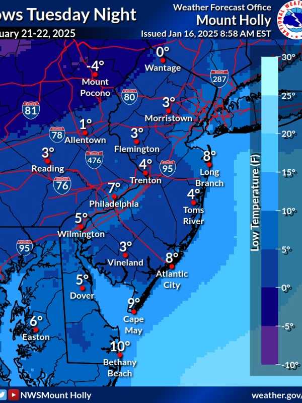
Arctic Blast Will Follow Snow Showers Across PA With Temps We Haven't Seen In Years, NWS Says Light snow showers are forecast to begin Thursday afternoon, Jan. 16 across parts of New Jersey and Pennsylvania, potentially creating slippery conditions during the evening commute, according to the National Weather Service (NWS).  A Hazardous Weather Outlook has been issued for several northeast New Jersey counties, including Passaic, Hudson, Bergen, Essex, and Union, with snowfall set to begin after 4 p.m. Most areas are expected to see less than one inch of snow, though localized accumulations of up to two inches are possible in parts of eastern Pennsylvania near and north of …
Back-To-Back Winter Storms Taking Aim On Northeast: Here's Latest Back-To-Back Winter Storms Taking Aim On Northeast: Here's Latest
Back-To-Back Winter Storms Taking Aim On Northeast: Here's Latest Back-to-back storm threats are on target for the Northeast in the coming days. New Update: First Snowfall Projections Released For New Winter Storm -  Up To Half-Foot Predicted In These Spots The first system will move from the west to the east, bringing a mix of rain, sleet, and snow Friday night, Jan. 17 into Saturday, Jan. 18. (See the first image above from AccuWeather.) More widespread wintry travel possible from a separate system Sunday night, Jan. 19 into Martin Luther King Jr. Day on Monday, Jan. 20.  It will range from the coastal to the interior Southeast. (Click on …
La Niña Is Now Here: What It Means For Winter Weather Patterns La Niña Is Now Here: What It Means For Winter Weather Patterns
La Niña Is Now Here: What It Means For Winter Weather Patterns She’s back!  La Niña has arrived, and its global ripple effects are already taking shape.  Cooler-than-average sea surface temperatures in the tropical Pacific, combined with stronger trade winds, are influencing weather patterns worldwide.  The National Oceanic and Atmospheric Administration (NOAA) confirmed this shift on Thursday, Jan. 9. What Is La Niña? La Niña is part of the El Niño-Southern Oscillation (ENSO), a natural climate phenomenon that disrupts atmospheric circulation.  During La Niña, cooler Pacific waters can lead to significant changes in rainfall, s…
6 To 8 Inches Of Snow Could Fall In Parts Of NJ, PA: Here's The Latest Winter Storm Forecast 6 To 8 Inches Of Snow Could Fall In Parts Of NJ, PA: Here's The Latest Winter Storm Forecast
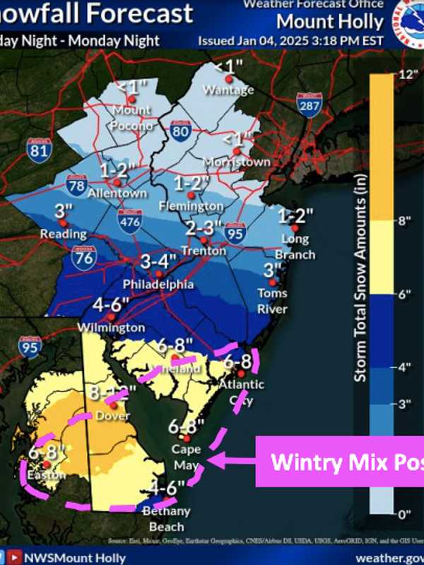
6 To 8 Inches Of Snow Could Fall In Parts Of NJ, PA: Here's The Latest Winter Storm Forecast The first significant snowstorm of 2025 is expected to hit the region Sunday night, Jan 5, bringing up to 8 inches of snow to parts of New Jersey and Pennsylvania, according to the National Weather Service. The storm is expected to begin late Sunday night, continuing through Monday, Jan. 6 before tapering off into Monday night.  Snow accumulations are forecast across the region, with the highest totals predicted in South Jersey (Vineland, Atlantic City, Cape May) and Philadelphia, where snowfall could reach 6 to 8 inches, new weather maps show.  Greater Philadelphia could see 3 t…
Cross-Country Storm Packed With Snow, Ice Takes Aim On Northeast Cross-Country Storm Packed With Snow, Ice Takes Aim On Northeast
Cross-Country Storm Packed With Snow, Ice Takes Aim On Northeast A quick-moving New Year's Eve storm system that brought some natural fireworks as 2025 arrived will be followed by strong wind gusts of up to 50 miles per hour that could lead to power outages before a winter storms makes its way to the East Coast. Temps will become more seasonable on Thursday, Jan. 2, with lingering strong winds making it feel colder. From Friday, Jan. 3 to Sunday, Jan. 12, temperatures will be between 12 and 25 degrees below the historical average.  The return of colder air will set the stage for a massive storm that will move along a 1,500-mile-long zone from the M…
Freezing Rain To Glaze Roadways With Ice: Winter Weather Advisories Issued Across NJ, PA Freezing Rain To Glaze Roadways With Ice: Winter Weather Advisories Issued Across NJ, PA
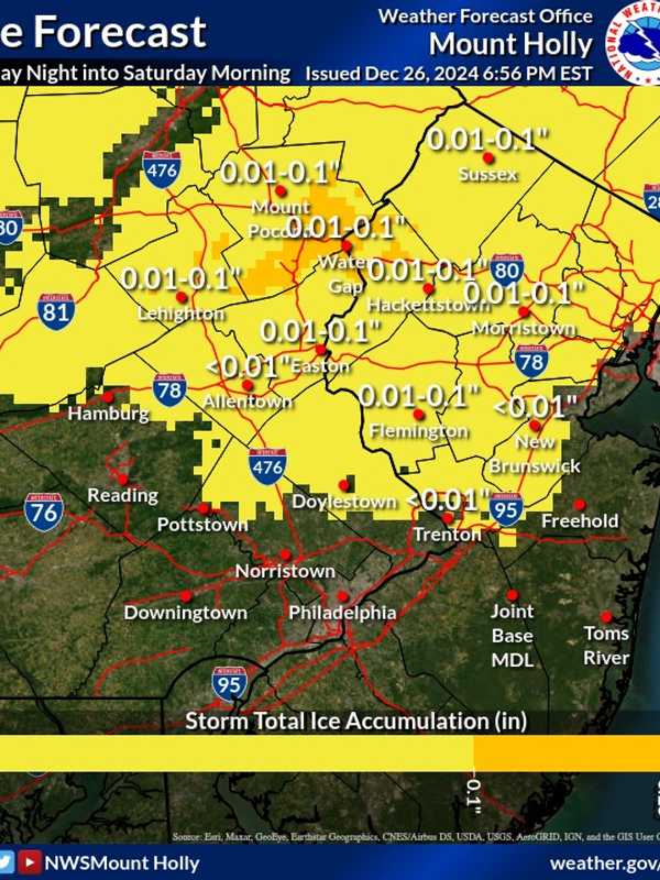
Freezing Rain To Glaze Roadways With Ice: Winter Weather Advisories Issued Across NJ, PA A Winter Weather Advisory has been issued for parts of New Jersey and Pennsylvania as freezing rain is expected to create icy road conditions Friday night, Dec. 27 into Saturday morning, Dec. 28, according to the National Weather Service (NWS). The advisory is in effect from 7 p.m. Friday to Saturday. Ice accumulations of up to one-tenth of an inch are anticipated in Sussex, Warren, and Morris counties, in NJ, and Lehigh and Northampton counties, in PA. "Very slippery sidewalks, roads, and bridges are possible," the NWS warned. Motorists are urged to slow down and exercise caution while dri…
1 To 3 Inches Of Snow Expected This Weekend In Parts Of NJ, PA: Here's Your Forecast 1 To 3 Inches Of Snow Expected This Weekend In Parts Of NJ, PA: Here's Your Forecast
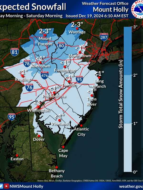
1 To 3 Inches Of Snow Expected This Weekend In Parts Of NJ, PA: Here's Your Forecast A weak winter system is expected to bring a mix of light snow and rain to parts of New Jersey and Pennsylvania beginning Friday morning, Dec. 20, and lasting into early Saturday, Dec. 21, the National Weather Service (NWS) in Mount Holly said. A weak system will move through Friday into early Saturday morning, bringing a mixed bag of wintry weather across the... Posted by US National Weather Service Philadelphia/Mount Holly on Thursday, December 19, 2024 The Poconos and northwest New Jersey are expected to see the most snow, with accumulations ranging from 1 to 3 inches. Areas north…
Light Snow Dusts Berks County, Huffs Church Reports 0.3 Inches Light Snow Dusts Berks County, Huffs Church Reports 0.3 Inches
Light Snow Dusts Berks County, Huffs Church Reports 0.3 Inches The National Weather Service has released snow totals from this week's winter storm. Snowfall accumulation impacted areas across New Jersey, Pennsylvania, Connecticut, and New York, with Sussex County, NJ, and Putnam County, NY, seeing the highest totals from Sunday, Dec. 15 into Monday, Dec. 16. Below are detailed figures reported by state, county, and town, as per the National Weather Service: New Jersey Mercer County: Trenton Mercer Airport: Trace (11:59 PM, 12/15) Morris County: Butler (1 S): 3.0 inches (5:15 AM, 12/16) Sussex County: Wantage Twp: 4.1 inches (5:00 AM, 12/16) Wan…
Long-Range Forecast Reveals Separate Storm Chances Christmas Week Long-Range Forecast Reveals Separate Storm Chances Christmas Week
Long-Range Forecast Reveals Separate Storm Chances Christmas Week Dreaming of a White Christmas? You may get your wish. Long-range weather models indicate the chance for two separate storm systems during Christmas Week, occurring right before and after Wednesday, Dec. 25. The first system is anticipated on Monday, Dec. 23. With overnight low temperatures in the upper teens and low 20s, and daytime highs around the freezing mark, the precipitation is likely to fall as snow.   The second chance for a storm that week will occur on Thursday, Dec. 26, when high temperatures are expected to reach the upper 30s to low 40s, which could result in r…
Flash Freeze, Snow Squalls To Hit PA: PennDOT Implements Restrictions, Crews On Patrol Flash Freeze, Snow Squalls To Hit PA: PennDOT Implements Restrictions, Crews On Patrol
Flash Freeze, Snow Squalls To Hit PA: PennDOT Implements Restrictions, Crews On Patrol PennDOT is preparing for a dangerous winter storm set to bring snow squalls, icy roads, and potential flash freeze conditions across Pennsylvania starting early Thursday, Dec. 5. Crews will begin road patrols as early as midnight in some areas, and vehicle restrictions will go into effect to ensure safety. Early Patrols and No Pretreatment Crews in Dauphin County will begin operations at 12 a.m., with other counties in the region starting patrols at 4 a.m., according to PennDOT spokesperson Fritzi Schreffler. Due to forecasts predicting initial rainfall, PennDOT will not pretreat roads, a…
What Are Snow Squalls? Winter Weather Hazard Forecast In NJ, PA: Here's What To Know What Are Snow Squalls? Winter Weather Hazard Forecast In NJ, PA: Here's What To Know
What Are Snow Squalls? Winter Weather Hazard Forecast In NJ, PA: Here's What To Know A storm system moving in brings the potential for snow squalls, 55 mph winds, and frigid temps mid-week in New Jersey and Pennsylvania, forecasters have said in a new update. ⚠️❄️🌬️ Not much change to the forecast for tonight through Thursday. Some snow showers may result in some light... Posted by US National Weather Service Philadelphia/Mount Holly on Wednesday, December 4, 2024 A powerful cold front is set to sweep through the region tonight into Thursday, Dec. 5, bringing snow showers, potential travel hazards, and wind gusts as high as 55 mph, according to the National Weather …
Here's How Many Major Hurricanes Hit During 2024 Atlantic Season Here's How Many Major Hurricanes Hit During 2024 Atlantic Season
Here's How Many Major Hurricanes Hit During 2024 Atlantic Season It's a wrap. The 2024 Atlantic hurricane season officially ended on Saturday, Nov. 30, with above-average activity in terms of the number of named storms, hurricanes, and major hurricanes. In total, there were: 18 named storms 11 hurricanes 5 major hurricanes (Category 3 or higher) This season was about 34 percent above the long-term average for Accumulated Cyclone Energy (ACE), which measures the strength and duration of tropical storms and hurricanes.  Below is a summary of the season’s named storms, with the five Cat 3 or higher hurricanes in bold: Tropical Storm Alberto (June 1…